|
|
April 20, 2001
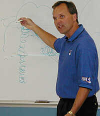
John Belski Visits and Talks About the Weather
|
|---|
John Belski is one of WAVE-TV's Storm Center 3 meteorologists. Along with Tom Wills and Kevin Harned, the team has provided Kentuckiana with the most accurate forecast for years. They are the official weather station for Jefferson County's 911 system and are the only local weather team with everyone approved by the American Meteorological Society. They have been voted Best of Louisville for the past fifteen years.

|

|
With the BARS repeater being part of SKYWARN operations, learning more about the weather can be an important part of amateur radio. SKYWARN spotters relay vital weather information directly back to the National Weather Service Office in Louisville. Radar cannot do the full job of storm watching; it takes eyes as well. With this in mind, we were thrilled to have John Belski visit us to share his knowledge of the weather with us.
Watches are issued out of Norman, Oklahoma and are updated twice a day. They provide a risk outlook of slight, moderate or high. A slight risk outlook means severe thunderstorms are likely. Moderate indicates winds, hail or tonadoes. A high risk outlook warns of large damaging tornadoes or other severe weather event.
A thunderstorm warning is issued when winds reach 58 mph or higher. It is also issued when hail sizes reach over 3/4 inches in diameter. And speaking of hail, we frequently hear about different types of hail, like marble-sized or other terms. John explained that to us.

There has only been one storm in Louisville in the last 2-1/2 years with hail as large as a tennis ball. Softball-sized hail is extremely rare in this area.
This region of the country is good for tornadoes. Hot dry wind out of the west combines with the cold from the north and the heat from the south making conditions ideal for dangerous storms. The best time for these storms to develop is in the heat of the day, usually from around 3 in the afternoon to 8 or 9 in the evening. Tornadoes are described using the F-Scale. This ranges from F0, being the weakest, to the strongest and most damaging at F5. It isn't until after the damage is assessed that the intensity of the storm is reported. Below is a chart explaining the levels.
|
Tornado F-Scale |
|
Classification |
Speed/Width |
Damage Caused |
|
F0 Very Weak
Tornado |
40 - 72 mph (65% of all tornadoes) |
Damages chimneys or TV antennae; breaks branches off trees; pushes over shallow-rooted trees; old trees with hollow inside break or fall; sign boards damaged. |
|
F1 Weak
Tornado |
73 - 112 mph (25% of all tornadoes) |
Peels surface off roofs; windows broken; trailer houses pushed or overturned; trees on soft ground uprooted; some trees snapped; moving autos pushed off the road. |
|
F2 Strong
Tornado |
113 - 157 mph 100-200 yards wide (7% of all tornadoes) |
Roof torn off frame houses leaving strong upright walls standing; weak structure or outbuildings demolished; trailer houses demolished; railroad boxcars pushed over, large trees snapped or uprooted; light-object missiles generated; cars blown off highway; block structures and walls badly damaged. |
|
F3 Severe
Tornado |
158 - 206 mph 200 yards - 1/4 mile across (2.5% of all tornadoes) |
Roofs and some walls torn off well-constructed fame houses; some rural buildings completely demolished or flattened; trains overturned; steel framed hangar-warehouse type structures torn; cars lifted off ground and may roll some distance;
most trees in a forest uprooted, snapped, or leveled; block structures often leveled. |
|
F4 Devastating
Tornado |
207 - 260 mph 1/4 - 1 mile across (0.5% of all tornadoes) |
Well constructed frame houses leveled, leaving piles of debris; structures with weak foundation lifted, torn, and blown off some distance; trees debarked by small flying debris; sandy soil eroded and gravels fly in high winds; cars thrown some distances or rolled considerable distances. |
|
F5 Incredible
Tornado |
261 - 318 mph 1/2 - 2 miles across (Average of less than 1 per year.) |
Strong
frame houses lifted clear off foundation and carried considerable distance; steel reinforced concrete structures badly damaged; automobile-sized missiles fly through the distance of 100 yards or more; trees debarked completely. |
|
One of the biggest tornado systems in history hit the Louisville area on April 3, 1974. Across 13 states, within a 24 hour period, 148 tornadoes were tracked by radar. There were six F5 tornadoes (one of which hit Brandenburg) and thirty F4 tornadoes. The storm was responsible for 315 deaths, 5484 injuries and $500 million in damage.
| 
|
 |
 |
| Photos of Brandenburg, KY before and after the April 3, 1974 tornado.
|
|---|
|
Although these storms are devistating, they can be interesting as well. There were reports of local books falling out of the sky as far away as Cincinnati caused by the Brandenburg tornado. The longest distance away for debris was a check found in Pennsylvania.
| 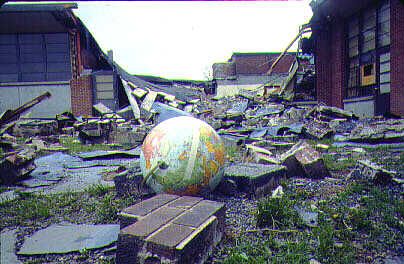
Audubon School after the tornado.
|
|---|

|
The most recent devastating tornado in this area was on May 28, 1996. This F4 tornado ripped through Bullitt County with winds of 220 miles per hour. The storm was on the ground for over ten minutes and was 1/3 of a mile wide. Like this home in Pioneer Village, there was little left by the storm.
|
Although tornadoes are destructive, it is not the most hazardous in the terms of loss of human life. Here are the top 6 most dangerous types of weather.
- Floods (Flash Flood)
- Lightning
- Heat
(A 105 degree heat index is very dangerous for outdoor activities.)
- Cold (Many heart attacks related to shoveling show.)
- Tornadoes
- Hurricanes
|
BARS thanks meteorologist John Belski for his fascinating and entertaining presentation on the weather. For more weather information, you can always go to www.wave3.com or just click on the links below. Your personal forecast is also waiting, free from WAVE-TV3.
|
|